
Where is Tonga?
Tonga, officially called the Kingdom of Tonga is a Polynesian kingdom situated in the South Pacific Ocean, nearly 2000 miles east of Brisbane, Australia. It is also named as “The Friendly Islands” . There are over 170 islands divided into four major island groups:
- The Tongatapu Group
- The Ha’apai Group
- The Vava’u Group
- The Tongan Niuas Group
“Nuku’alofa” which is located on the islands of Tongatapu is the capital of Tonga.
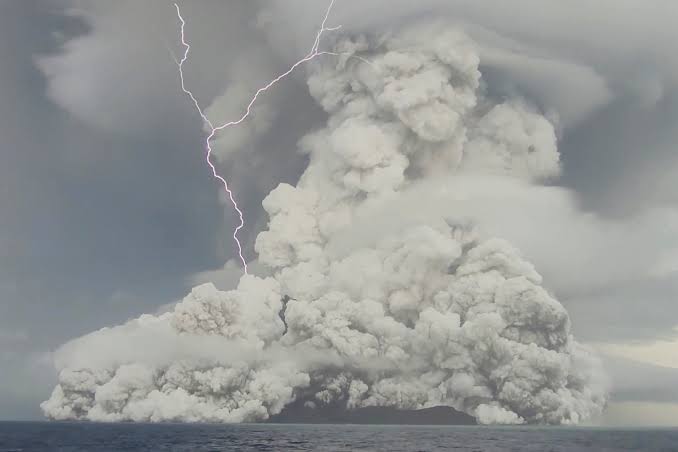
Submarine Volcano Eruption & Impacts
The Hunga-Tonga-Hunga-Ha’apai is an underwater volcano, located about 30 kilometers (19 miles) southeast of Tonga’s Fonuafo’ou island. This submarine volcano erupted on 14th January and half the world experienced pressure waves the following day.
As per the NASA Earth Observatory, the Hunga-Tonga-Hunga-Ha’apai volcano spewed debris as high as 40 kilometers (25 miles) into the atmosphere during the 15th January volcanic eruption which triggered huge tsunami waves.
The Hunga-Tonga-Hunga-Ha’apai volcano had erupted earlier in the year 2009, 2014 and 2015. The explosion of hot jets of magma and steam was observed, but these are minor events when compared with the January 2022 volcanic eruption.
According to the research, this is one of the massive explosions the volcano is capable of producing roughly every 1000 years.
The NASA scientists have analysed that, the volcanic blast that thunderstruck the South Pacific Kingdom of Tonga earlier this month was about hundreds of times more powerful than the atomic bomb dropped on Hiroshima, Japan, during World War II.
As per their estimation the amount of energy released by the submarine volcanic eruption was equivalent to over 10 megatons of TNT.
The colossal event covered the island kingdom of about 100,000 in a thick layer of volcanic ash cloud. The gasses and particles emitted from the eruption have a devastating impact on Tongan islands. The water sources were polluted. It also severed the internet cable, which cut off communication to the remote archipelago for days. The airport covered in ash prevented the arrival of relief flights at Nuku’alofa.
The Government of Tonga along with humanitarian partners had reported that the entire population of Tonga (approximately 105,000 people) were affected by the ash and the tsunami.
Death of three was confirmed. People from Mango Island were evacuated to Nomuka Island and on 21st January to Tongatapu. Nearly 3,000 people had to seek shelter on higher grounds, with relatives and friends or in evacuation centers, but later the majority of them were able to return home.
As per United States Geological Survey (USGS) data, days after the devastation, on Thursday, a magnitude 6.2 earthquake was recorded off the coast of Tonga at 0640 GMT.
The quake struck at a depth of 14.5 kilometers (9 miles) and the epicenter was located 219km (136 miles) northwest of Pangai, a village on the remote island of Lifuka.
Now, to study volcanoes and predict eruptions scientists are using drones that are specifically designed for scientific uses in challenging environments. These drones are helpful where remote but dangerous volcanoes are consistently monitored for activity.